Coastal Explorer let you choose the types of charts you want to use. You can even quilt several types of charts together!
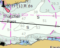
VECTOR CHARTS
 Coastal
Explorer uses S-57 ENC vector charts which are the only official vector
charts produced by NOAA and the hydrographic offices in most of the rest of the
world. Charts for most US waters are available free of charge from the
NOAA and US Army Corps of Engineers websites and Coastal Explorer makes it very
easy to download and install these charts.
Coastal
Explorer uses S-57 ENC vector charts which are the only official vector
charts produced by NOAA and the hydrographic offices in most of the rest of the
world. Charts for most US waters are available free of charge from the
NOAA and US Army Corps of Engineers websites and Coastal Explorer makes it very
easy to download and install these charts.
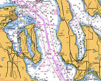
RASTER CHARTS
 If you
prefer to use the older "raster" charts, or vector charts are not yet available
for some of your favorite cruising spots, Coastal Explorer will also let you use
raster charts in most popular formats, including the new BSB4 format from
Maptech and NDI. Coastal Explorer includes Chart Kit / MAPTECH
Region 1 - United States Planning Charts - a $199.95 value!
If you
prefer to use the older "raster" charts, or vector charts are not yet available
for some of your favorite cruising spots, Coastal Explorer will also let you use
raster charts in most popular formats, including the new BSB4 format from
Maptech and NDI. Coastal Explorer includes Chart Kit / MAPTECH
Region 1 - United States Planning Charts - a $199.95 value!
PHOTO CHARTS
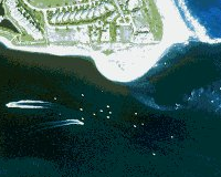 Photo charts
are not intended for navigation, but can be a very handy to supliment to your
charts. Coastal Explorer supports photo charts from Maptech, SoftChart
International, and even GeoTIFF format images you can download from the
Internet.
Photo charts
are not intended for navigation, but can be a very handy to supliment to your
charts. Coastal Explorer supports photo charts from Maptech, SoftChart
International, and even GeoTIFF format images you can download from the
Internet.
TOPOGRAPHIC MAPS
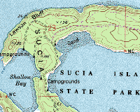 Topographic
maps are not suitable for navigation either, but are very handy for hiking
around that island you just anchored near! Coastal Explorer can use the
topographic maps that are included in many of Maptech's ChartKits as well as the
original USGS DRG files which are found in the GeoTIFF format.
Topographic
maps are not suitable for navigation either, but are very handy for hiking
around that island you just anchored near! Coastal Explorer can use the
topographic maps that are included in many of Maptech's ChartKits as well as the
original USGS DRG files which are found in the GeoTIFF format.
Electronic Chart Manufacturers
Coastal Explorer can use charts and maps from these agencies and manufacturers:
 |
|
 |
|
 |
|
COPYRIGHT © 2003-2004 ROSE POINT NAVIGATION SYSTEMS, LLC. ALL RIGHTS RESERVED.