|
Navigation
Software Just Got a Lot Better |
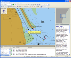
Coastal Explorer™ is a sophisticated and full-featured, yet very easy to use navigation software package designed specifically for the pleasure boater.
With support for official raster and vector charts from almost every major hydrographic agency in the world, route planning features with multi-level undo capability, integrated gazetteer and Coast Pilot™ books, virtual instrument display, and obstacle alerts, Coastal Explorer will help you make your next cruise safer and more enjoyable.
Here are just some of the features provided by Coastal Explorer:
Chart
Compatibility - MapTech/BSB and SoftChart Raster Nautical Charts and the
S-57 Electronic Navigation Charts (ENC) are all fully supported. ![]() More info...
More info...
Simple, automatic chart installation - no "dongles" are necessary and charts almost install themselves!
Advanced
chart collection management - find out what charts you have, where they
are, and how old they are, and even move them around with the only Chart
Portfolio to include list, thumbnail, and world-map views. ![]() More info...
More info...
Chart quilts combining raster, vector, and photo charts - combine different types of charts together in one seamless "quilt".
Instrument Compatibility - Works with any NMEA 0183 compatible GPS with suitable PC interface. Also works with other NMEA 0183 compatible equipment including: autopilots, depth/speed/temperature sensors, anemometers (wind), ARPA/MARPA RADAR, and AIS receivers.
Virtual
Instrument Displays - see important information at a glance with your
choice of digital or analog style on-screen "virtual instruments". ![]() More info...
More info...
Route checking and obstacle alerts - utilizing state-of-the-art vector chart databases, Coastal Explorer will check for obstacles along your route before you embark and while under way.
Super-integrated gazetteer and Coast Pilot™ - a gazetteer covering all of North America is included and world-wide coverage is available as a free add-on; millions of places are named and it couldn't be simpler to find any one of them. Plus, you can look up a place in the United States Coast Pilot™ books with just one or two mouse clicks.
Multi-level undo/redo capability - any changes you make to your Navigation Objects can be undone.
To Use Coastal Explorer, you need:
- PC with Pentium 350 MHz or higher processor, Pentium III or higher recommended.
- Microsoft Windows 2000, Windows XP or higher operating system.
- 128 MB of RAM or above. More is recommended, especially when using raster charts.
- 500 MB of available hard-disk space (requirements depend on installation options).
- Super VGA (800x600) or higher resolution monitor. 1024x768 or higher is recommended.
- GPS with appropriate PC interface required for some features.
COPYRIGHT © 2003-2004 ROSE POINT NAVIGATION SYSTEMS, LLC. ALL RIGHTS RESERVED.


