|
Typical
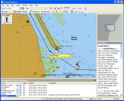
Planning Mode Screen 
|
Coastal Explorer makes it easy to plan your next cruising adventure with features like chart quilting, multi-level undo, a super-integrated gazetteer, a completly geo-referenced Coast Pilot, and route obstacle detection. With chart quilting, there's no need to figure out which charts to open. Just zoom in and out and scroll around and the right charts will appear seamlessly quilted together. Don't worry about making mistakes as you modify your route plan since you can always undo! The gazetteer includes millions of places in the US, Canada, and Mexico and more countries are available. You can find any of these places by simply entering a name in the box on the toolbar! The US Coast Pilot is tightly integrated into Coastal Explorer's charts. Just click somewhere and find out what the Coast Pilot has to say! Obstacles along your route are pointed out to you as you are planning to help you plan a safe trip. You can also maintain a separate collection of waypoints, routes, tracks, and boundaries for each trip (if you like). Coastal Explorer uses documents instead of a hidden database to keep track of all of your Navigation Objects so you can organize them however you want. You can even share them with your friends using e-mail, floppy disks, or USB Flash Drives! |
COPYRIGHT © 2003-2004 ROSE POINT NAVIGATION SYSTEMS, LLC. ALL RIGHTS RESERVED.
